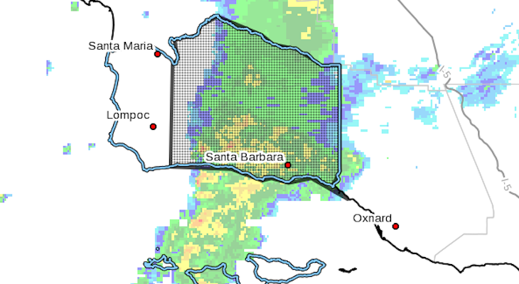
The National Weather Service has issued a SIGNIFICANT WEATHER ADVISORY FOR CENTRAL SANTA BARBARA COUNTY UNTIL 730 AM PST…
NWS Doppler radar was tracking a couple of rotating storms in the Santa Barbara Channel that will bring brief periods of heavy rain, small hail, and the possibility of funnel clouds or weak tornadoes between Refugio State Beach and Goleta.
Half inch hail and wind gusts up to 50 mph will be possible with this storm.
Locations impacted include…El Capitan State Beach…Refugio State Beach…Isla Vista…Summerland…Goleta.
Aviso de clima severo. Hasta las 7:30 am. Area entre de Refugio y Summerland. Breves periodos de lluvia intensa, granizo pequeño y la posibilidad de nubes de embudo o tornados debile. Tome accion para mantenerse a salvo.
The National Weather Service in OXNARD has issued a
* Urban and Small Stream Flood Advisory for… Santa Barbara County in southwestern California…
* Until 730 AM PST.
* At 545 AM PST, Doppler radar indicated a fairly narrow line of heavy showers moving across western Santa Barbara County. Rainfall rates within this band of rain were between 0.25 and 0.50 inches per hour. Heavier embedded quick moving showers will likely produce briefly higher rainfall rates. This band of showers will move across the county through 730 AM PST, then should exit the county. It will affect the Whittier and Sherpa burn areas from about 615 AM to 645 AM, and the Santa Barbara County portion of the Thomas Burn area from about 645 AM to 730 AM PST.
* The rain will cause widespread ponding of water on area roadways and flooding of low lying areas and intersections. In the Whittier and Sherpa burn areas, and the Santa Barbara County portion of the Thomas Burn area, the rain may cause mudslide and rockslides, and possibly some shallow debris flows.
* When driving, Be prepared for a sudden change to near zero visibility as these showers quickly move through the area.
* Some locations that will experience flooding include… Buellton, Santa Ynez, Solvang, Refugio, Lake Cachuma, Gaviota, Goleta, Santa Barbara, Montecito, Isla Vista and Carpinteria, and the Whitter, Sherpa and Santa Barbara County portion of the Thomas Burn area.
PRECAUTIONARY/PREPAREDNESS ACTIONS…
Turn around, don’t drown when encountering flooded roads. Most flood deaths occur in vehicles.
Move away from recently burned areas. Minor flooding of creeks, roads and normally dry arroyos is likely. The rain may trigger shallow mud and debris flows, minor rock falls, and flooding capable
of localized damage, especially in steep terrain near burn scars.


