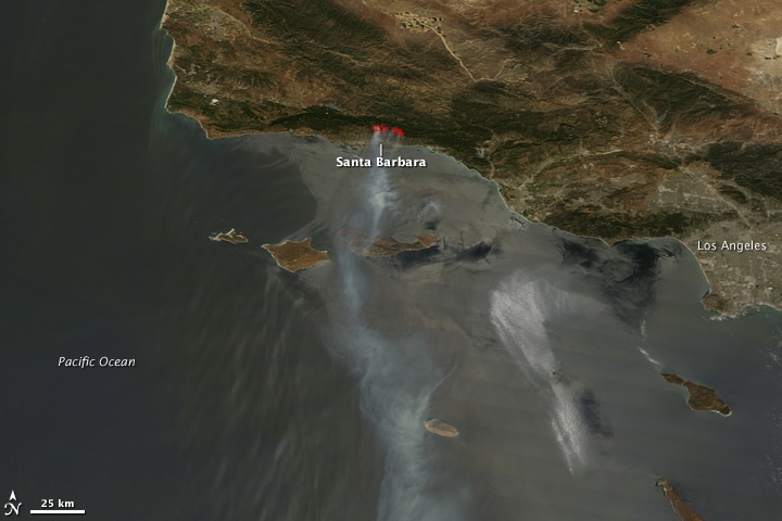
Today marks the 15th anniversary of the Jesusita Fire, an event that left an indelible mark on the Santa Barbara community. The wildfire, which ignited on May 5, 2009, quickly spread to over 8,700 acres, devastating wildlife habitats, and challenging local firefighting resources.
Over the span of approximately three weeks, the Jesusita Fire destroyed 80 homes, damaged 15 others, and resulted in nearly 30 injuries to firefighters, three of whom required hospitalization for second and third degree burns, who battled against the flames. While the community was fortunate to have no fatalities among its residents, the fire served as a severe reminder of the vulnerability of the region to wildfire threats.
The wildfire began as a small blaze along the Jesusita Trail just below Cathedral Peak but grew rapidly, accelerated by the combination of intense winds, dry conditions, and dense brush, which is characteristic of the Santa Barbara front country.
Within a matter of hours the fire had grown to 150 acres. At its peak, the blaze forced the evacuation of approximately 30,000 residents, as schools were closed, roads were shut down, and the skies above Santa Barbara filled with the smoke and ash.

The fire perimeter extended west of Highway 154, in the hills burned in the 1990 Painted Cave Fire, across the front country of the Santa Ynez Mountains east through Mission Canyon, Rattlesnake Canyon, and into the hills above Montecito, reaching the area burned by the Gap Fire in July 2008 and the Tea Fire in November 2008. The fire was fully contained on May 18.
In December 2009, Craig Ilenstine and Dana Larsen were charged with operating a weed whacker without a hot work permit, a charge typically associated with activities like welding, not trail clearing. Despite not being proven responsible for starting a fire, they faced misdemeanor charges for this permit issue and, in July 2010, both pleaded no contest, resulting in 250 hours of community service, three years probation, and a $490 fine each. The legal situation took a further turn when, in July 2011, 60 homeowners affected by the fire sued the equipment manufacturer, Stihl Incorporated, for not warning that the cutter’s metal blades could spark fires, leading to a settlement in July 2013 for an undisclosed sum.
In the 15 years since the disaster, residents and policymakers alike have taken measures to reduce the risk and enhance response to wildfires. These actions include the clearing of firebreaks, improvements in public alert systems, and investments in firefighting technology.

“Fire season is coming: Today marks 15 years since the 2009 Jesusita Fire, one of Santa Barbara County’s most devastating events—80 homes lost, 8,733 acres burned. For more on safety, visit: http://sbcfire.com/ready-set-go/ & safety alerts @ http://Readysbc.org. Stay safe!” wrote County Fire Captain Scott Safechuck on X.
As the community looks back on this somber milestone, the message resonates loud and clear: preparedness can save lives, homes, and the natural beauty that Santa Barbara cherishes.


Many of us remember each one of the fires mentioned in this article. Unfortunately the county opted to rezone land for high density housing where Jesusita, 2009, Paint 1990 and the cave fire 2019 have all burned. Both sides of 154 north of Cathedral Oaks have been given the green light for low income apartment buildings. 20/30 units per acre. Poor planning putting the most vulnerable renters in very high fire hazard zones.
The best way to avoid fires is not to buy/build in the forests.
Good luck getting Home insurance coverage in the Glen Annie canyon area too. Genius plan guys!
I know that the Glen Annie Golf Course area is being rezoned to allow over 1000 units, but where are there other areas north of Cathedral Oaks that are being rezoned? I’m not familiar with any–saw the list on the article this week about rezoning, but don’t know where some of the named parcels are located. Is there one or more east of 154 and north of Cath Oaks?
St Vincent’s East & West straddle 154 North of Cathedral Oaks/ Foothill Rd. The East parcel currently has a grove of oak trees and is directly below the San Marcos Foothills Preserve. The Western Parcels are adjacent to the off-ramp and Via Chaparral, across the street from Rancho Santa Barbara.
That was a really scary time. Didn’t it also take firefighters a few hours to respond to this fire too?
Saw it start about 3pm from San Roque and knew it would go, couldn’t get any tankers in time, too late that afternoon so we booked one the last rooms at the Lemon Tree. Snuck back through the police and Humvee line ala El Pollo Loco to get stuff the next morning.
I worked for the County 2005-2010; supported fire/emergency efforts for every fire in that period. I felt good to be part of the effort, but am SO glad I’m retired. Used to live just below where Ross set fire to Linthicum’s property resulting in the Painted Cave fire. Enough trauma for my lifetime.